Rockstar has released the official map of GTA 6. On 19 November 2026, launch day, a free printable poster of Leonida went up on the downloads page of the official GTA VI site, next to a poster of the cover art. It names five counties, fourteen districts of Vice City, the islands of the bay, the Keys down to Mile Zero Air Station and dozens of landmarks, from the airport to the racetracks. You can explore it on our interactive GTA 6 map, which uses Rockstar's official map as its background.
| The official GTA 6 map | Details |
|---|
| Released | 19 November 2026, the day GTA 6 came out |
| Where | Downloads page of the official GTA VI site, artwork section |
| Price | Free to download; a paper copy is $0.99 on the Rockstar Store |
| File | Leonida_Map_Poster_Printable.zip, 45.4 MB, one JPEG inside |
| Image | 5,775 x 7,900 pixels at 300 dpi, in print colours (CMYK) |
| Print size | 19.25 x 26.33 inches (48.9 x 66.9 cm) |
| Scale printed on it | 1 inch = 0.5 mile, 2 inches = 1 mile |
| Counties | Lummox, Leonard, Kelly, Vice-Dale, Mariana |
How to download the official GTA 6 map
The map is on the downloads page of the official GTA VI site, in the artwork section, in a block titled after the Leonida map and the cover art poster. Rockstar presents both as print-ready files. You do not need to have pre-ordered the game to download them.
The map comes as a ZIP file of 45.4 MB, Leonida_Map_Poster_Printable.zip, which holds a single image, Leonida_Map_Poster_Printable.jpg. At 5,775 by 7,900 pixels and 300 dots per inch, it prints at 19.25 by 26.33 inches, or 48.9 by 66.9 cm, without losing sharpness. The file is saved in CMYK, the colour format print shops use, so it is ready to send to a printer as it is. Unzip it on a computer rather than a phone, since the image alone weighs more than 40 MB. The cover art poster is a separate download, Cover_Art_Poster_Printable.zip.
Can you get a paper GTA 6 map?
Yes, but not in the game box. Boxed copies of GTA 6 hold a download code and no paper map, while Rockstar's boxed games up to Red Dead Redemption 2 came with one. The $399.99 GTA 6 Collector's Box, sold without the game, does include a double-sided souvenir poster with a map of Leonida on one side. Rockstar announced before launch that a double-sided paper version of the map and poster would be sold on the Rockstar Store shortly after launch, for $0.99 on its own, or added as a free gift to any Rockstar Store order. Rockstar has not given a date for the paper version yet. Until then, the free download is the full map.
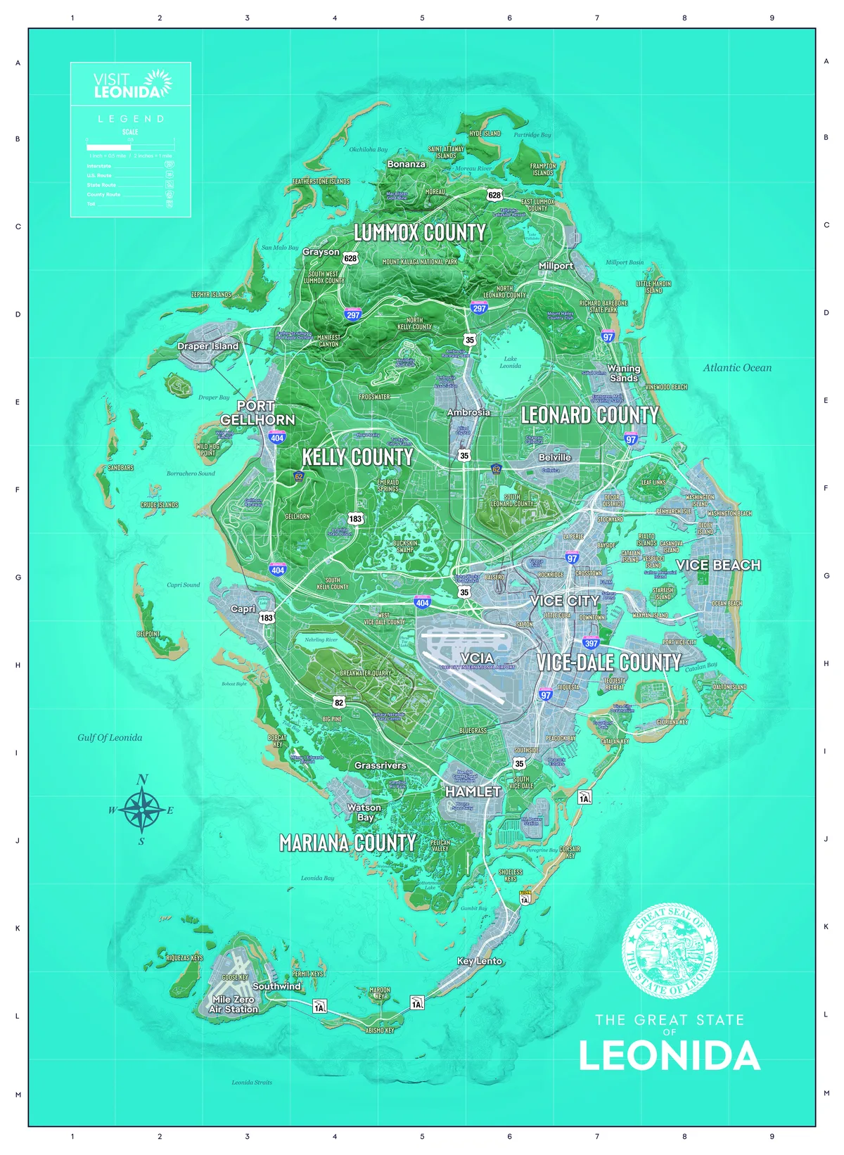 The Great State of Leonida, the official GTA 6 map. Image: Rockstar Games
What the official map shows
The poster is styled as a state tourism map. It is titled The Great State of Leonida, carries the Great Seal of the State of Leonida, a Visit Leonida panel with the legend, a compass rose and a grid of rows A to M and columns 1 to 9 for finding places. The legend sets the scale at 1 inch for half a mile and lists five kinds of road: Interstate, U.S. Route, State Route, County Route and Toll.
Leonida is split into five counties. The map prints their names across the land without drawing their borders, so it shows roughly where each one sits, not exactly where one ends and the next begins:
- Lummox County is printed across the north, over Mount Kalaga National Park, near Bonanza, Grayson and Millport.
- Leonard County is printed in the east, near Lake Leonida, Belville and Waning Sands.
- Kelly County is printed in the west, near Port Gellhorn and Gellhorn.
- Vice-Dale County is printed in the south-east, near Vice City and the airport.
- Mariana County is printed in the south-west, near Watson Bay and the Grassrivers.
The towns printed in large type are Vice City, Vice Beach, Port Gellhorn, Ambrosia, Hamlet, Grassrivers, Watson Bay, Key Lento, Belville, Waning Sands, Millport, Grayson, Bonanza, Draper Island, Capri and Southwind.
Vice City on the official map
Vice City sits on the east coast, between the airport and the bay. The map names fourteen districts and areas in and around it: Downtown, Little Cuba, Salton, Tequesta, Stockyard, Decor District, Bayside, Crosstown, Rockridge, Balsero, La Perle, Ocean Beach, Washington Beach and Port Vice City. Vice Beach, the long barrier island on the ocean side, has its own large label. Names that circulated before launch, such as Little Havana for the Cuban quarter, are not on the map: the official name is Little Cuba.
The bay between the city and Vice Beach is full of islands, each named: Rialto Islands, Vespucci Island, Casanova Island, Catalan Island, Starfish Island, Waxman Island, Oldby Island, Washington Island, Penmarch Isle, Leaf Links and Dalton Island. Interstate 97 runs north to south through the city, and Interstate 397 crosses it towards the port.
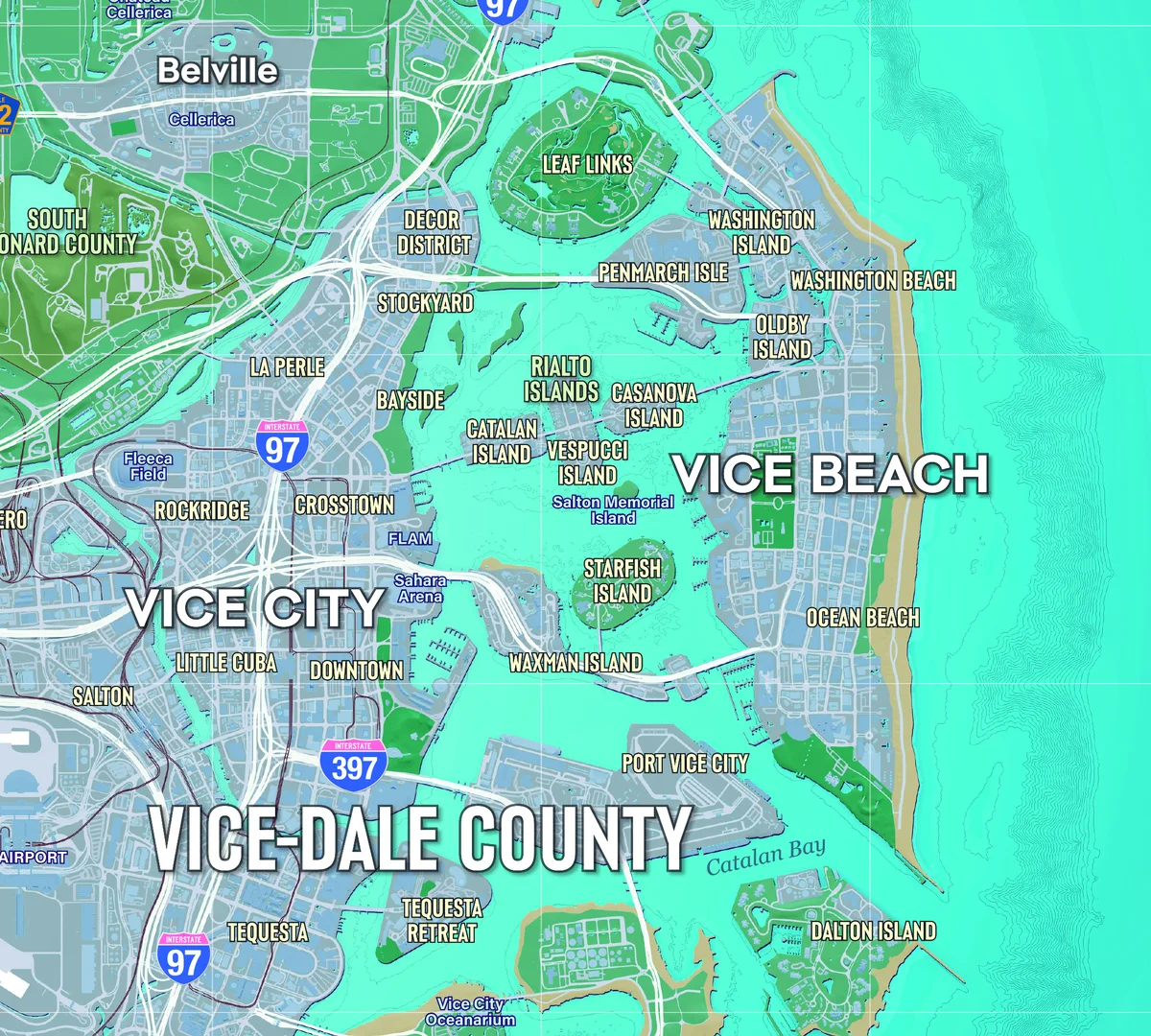 Vice City, Vice Beach and the islands of the bay on the official map. Image: Rockstar Games
The Keys and the south of Leonida
South of Vice City, State Route 1A, marked as a toll road, runs over the water to the Keys. Key Lento is the main town, and the chain ends at Mile Zero Air Station, next to Southwind and Goose Key. The other keys named on the map are Catalan Key, Gloriana Key, Shoeless Keys, Corsair Key, Maroon Key, Abismo Key, Permit Keys and Riquezas Keys. The Keys are where Jason lives when the story begins, as our GTA 6 story page explains without spoilers.
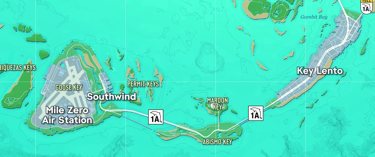 The Keys, from Key Lento to Mile Zero Air Station. Image: Rockstar Games
Landmarks named on the map
Beyond towns and districts, the map labels the places that matter in the game, several of them tied to activities and trophies:
| Landmark | Where on the map |
|---|
| VCIA, Vice City International Airport | West of Vice City |
| Sahara Arena, Fleeca Field | Vice City |
| Vice City Oceanarium | South of Vice City, by Catalan Key |
| Boone Speedway, Hamlet Correctional Institution | Hamlet |
| Gellhorn Raceway | South of Port Gellhorn |
| Wild Hog Airfield | Wild Hog Point, by Port Gellhorn |
| Ambrosia Raceway Park, Thrillbilly Mud Club, Ambrosia Rodeo Association, Allied Crystal | In and around Ambrosia |
| Lake Leonida | Next to Ambrosia, near the Leonard County label |
| Evergreen Mall of Waning Sands | Waning Sands, on the east coast |
| Richard Barebone State Park | North of Waning Sands |
| Mount Kalaga National Park | In the north, under the Lummox County label |
| Breakwater Quarry, Sahara Network Data Center | Between the airport and the Grassrivers |
| Tisha-Wocka Flea Market | West of Vice City |
| Paradise RV Park | Grassrivers |
| T.H. Power Station | South-east of Hamlet |
| Mile Zero Air Station | The far end of the Keys |
Gellhorn Raceway, Thrillbilly Mud Club and Boone Speedway are also race venues in the game, as our GTA 6 gameplay page lists with the other activities the trophies confirm.
Highways and roads of Leonida
Four interstates cross the state: I-97 along the east coast through Vice City, I-297 across the north, I-397 into Vice City and I-404 from Port Gellhorn towards the city. U.S. Routes 35, 183 and 82 link the inland towns, County Route 62 runs through Kelly and Leonard counties, route 628 climbs into Lummox County, and State Route 1A, the toll road, carries traffic to the Keys.
How big is the GTA 6 map?
Rockstar has not published a size for Leonida. The poster does print a scale, 2 inches to the mile, which is 600 pixels to the mile in the file. Measured with that scale, the land runs about 8 miles from west to east and 11 miles from north to south, islands included. That is our own measurement on Rockstar's poster, not a figure from Rockstar, and nothing says the scale of the poster matches the distances in the game. We have left out comparisons with GTA V's map until there is a measured in-game figure. What Rockstar's developers have said about the size of the world is on our GTA 6 map size guide.
Explore Leonida on our interactive GTA 6 map
Our interactive GTA 6 map of Leonida now uses Rockstar's official map as its background, credited to Rockstar Games. You can zoom into any district, switch layers on and off, and search 41 points: regions, places, Vice City districts, characters and activities. For the regions one by one and what Rockstar has said about each, see our GTA 6 map guide.
Frequently asked questions
Is there an official GTA 6 map?
Yes. Rockstar released the official map of Leonida on 19 November 2026, the day GTA 6 came out, as a free printable poster on the downloads page of the official GTA VI site.
How do you download the GTA 6 map?
Open the downloads page of the official GTA VI site and go to the artwork section. The map is a 45.4 MB ZIP file holding one image of 5,775 x 7,900 pixels at 300 dpi, which prints at 48.9 x 66.9 cm.
Does GTA 6 come with a paper map?
Not in the game box. The $399.99 GTA 6 Collector's Box, sold without the game, includes a double-sided poster with a map of Leonida. Rockstar also announced a paper map and poster for the Rockstar Store shortly after launch, at $0.99 on its own or free with any Rockstar Store order, without a date yet.
What are the counties of Leonida?
The official map names five: Lummox County in the north, Leonard County in the east, Kelly County in the west, Vice-Dale County in the south-east with Vice City, and Mariana County in the south-west.
How big is the GTA 6 map?
Rockstar has not given a size. Measured on the scale printed on the official poster, the land runs about 8 miles from west to east and 11 miles from north to south, but nothing says the poster's scale matches the game.